iMEASURE DATA COLLECTION APPLICATION
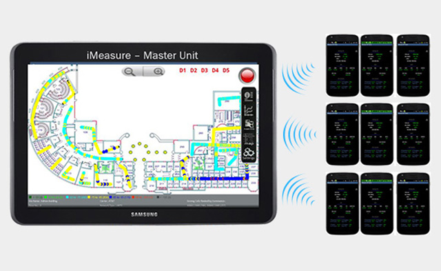
iMeasure© is an Android-based application for measuring wireless air interface that is compatible with both Android-based handset and tablet devices. iMeasure collects data from signal receivers connected via USB, enabling users to collect CW measurements and scan networks.
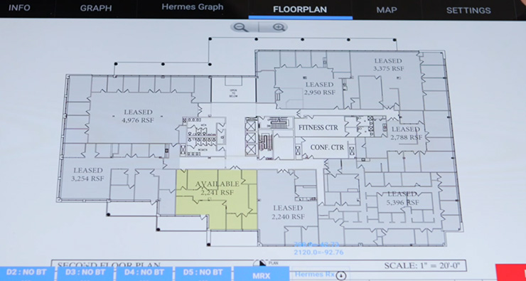
We’ve designed iMeasure© as a lightweight yet intelligent solution that is highly suitable for onsite troubleshooting and site surveys. Simply take a picture of the floor plan or upload an existing picture and start tapping the screen to place markers as you walk through the building. The state-of-the-art mapping algorithm converts the floor plan into a geodetic image and assigns coordinates to the collected measurements.
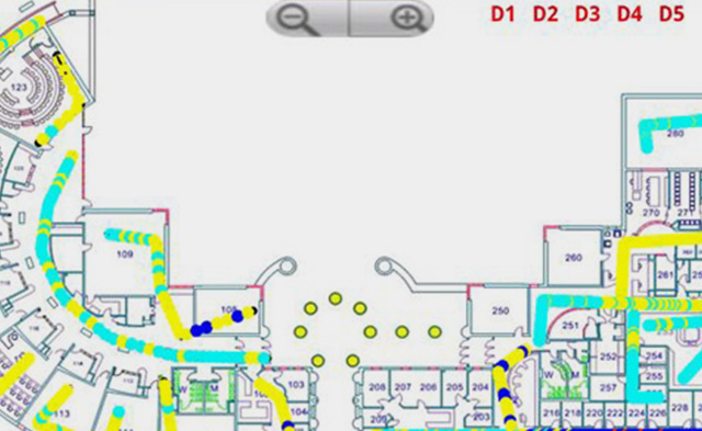
From there, the app traces and records locations and signals, allowing users to easily import the data to the mapping software of their choice for further analysis. The app also saves a snapshot of the results with the color-coded measurements directly on the device.
In addition to its indoor capabilities, iMeasure© also allows users to collect traditional drive testing data utilizing GPS coordinates. The app then overlays the collected data onto Google Maps directly on the mobile device during the drive test then saves the information to a log file for easy import into popular GIS tools.

The iMeasure© Data Collection App
iMeasure© Application
App Features

Simple App
The iMeasure© app is designed to be easy to use with powerful functionality for critical indoor testing.
Fully Integrated
With one app, you can collect data from multiple sources, including handsets, Wi-Fi, and signal receivers.


Multi-Handset
iMeasure© allows simultaneous streaming and data collection from multiple handsets, making testing easier and more accessible for planners.
Why Indoor Testing?
Indoor coverage testing is critical in evaluating and designing the micro/pico network layers to fill indoor coverage holes that macro networks may fail to reach. When assessing the need for an in-building solution, a thrall study can help determine the most economical design that complements the existing macro network with additional network elements.
iMeasure© plays an essential role in helping design engineers to easily and effectively assess the existing coverage and to narrow down the design objective. In busy office buildings, shopping malls, subways stations, and other spaces where it is difficult to carry bulky test equipment, iMeasure© is always conveniently and readily available in your pocket to conduct comprehensive coverage studies, radio interference analysis, and various test procedures that would otherwise pose logistical challenges.
Technology and Bands
iMeasure© Supports:
Lorem ipsum dolor sit amet, consectetur adipiscing elit. Ut elit tellus, luctus nec ullamcorper mattis, pulvinar dapibus leo.
- Wi-Fi
- GSM
- EDGE
- GPRS
- WCDMA
- HSUPA
- CDM
- EVDO
- HSPA
- LTE
- 5G
FAQs
iMeasure provides planners with a highly portable, easy-to-use measurement tool for wireless air interface. Since planners can load iMeasure onto Android devices, they can access best-in-class measurement tools from their smartphone or tablet.
Currently, iMeasure is supported on Android 9.0 or later devices with touchscreen display, Internet connectivity, and a camera. For certain measurements, iMeasure will require Bluetooth connectivity, GPS, and a USB port (for CW connectivity). Devices should have a minimum of 20 MB memory storage capacity, at least 1 GHZ processing power, and 1.5 GB RAM.
Yes, iMeasure provides X/Y coordinates with all metrics when used in indoor mode and latitude/longitude coordinates for all metrics when used in outdoor mode.
Yes, iMeasure can produce CW measurements when planners connect an additional CW receiver to their mobile device.
Yes, iMeasure can display real-time results for measurements such as signal strength as well as important information about the network that is being measured.
Yes, iMeasure allows planners to insert notes and comments during their recording, as well as insert pictures tagged to the location in which they were taken. Planners can also toggle between text and chart views on the go.
