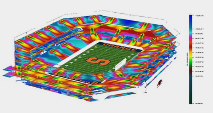
DASCAD does it differently. As a complete network planning platform, DASCAD provides both indoor and outdoor planning and optimization with 3D prediction and traffic mapping.
The DASCAD solution addresses network providers’ need for a high resolution hetronet platform capable of simulating all network elements—including Macro, Small Cells and DAS—in one platform.
DASCAD produces a complete picture of the RF environment without leaving out any signal source that should be considered during the design process. This enables engineers and decision makers to run and compare design and optimization scenarios before applying them to the live network.
Using DASCAD as part of the planning process can lead to better user experience during deployment, unlike legacy solutions which often plan and design network layers in isolated silos which are difficult to optimize.
The DASCAD Network Planning Platform
DASCAD Network Planning Platform
Product Features
One Platform for One Network
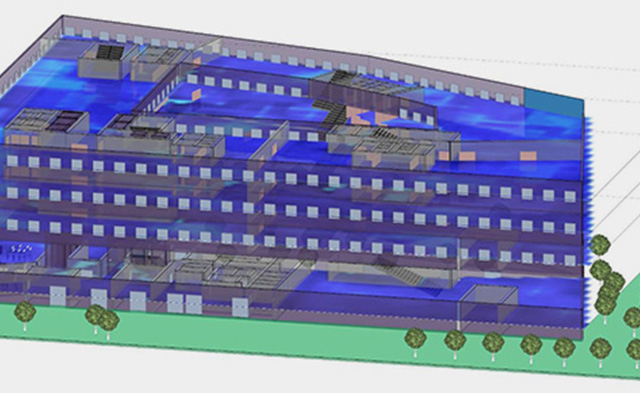
DASCAD models all network elements, including outdoor macro, small cells, and indoor DAS systems. These include accurate building modeling and building materials, detailed cable routing, and a regularly updated components database.
Under The Hood
DASCAD utilizes a state-of-the-art advanced ray tracing prediction engine to make 5G massive mimo simulation possible. In fact, DASCAD traffic simulation is the most advanced Monte Carlo simulation possible, allowing engineers to understand and simulate network traffic with live traffic data and the latest scheduler techniques.
Technology and Bands
DASCAD Supports
- GSM / EDGE / GPRS
- CDMA / 1xRTT
- iDEN
- TDMA
- HSPA / WCDMA
- 1xEV-DO
- TD-SCDMA
- LTE
- WiMAX (802.16)
- WiBro
- WiFi (802.11 a/b/g/n)
- RFID / Zigbee (802.15.4) / WMTS
- Cellular850 / PCS1900 / AWS2100
- GSM900 / DCS1800 / UMTS2100
- Public Safety 700 / SMR800-900
- TETRA / 450 MHz / Paging
- VHF / UHF
- WiFi 2400-5800
- WiMAX 2300-3400-5800
FAQs
Yes! We’ve designed DASCAD specifically to equip network planners with a unified design platform that provides insights into many different types of capacity planning. For example, DASCAD can handle macro, small cell, and DAS design, as well as manage all the data necessary for an integrated design, including:
- Social media data
- Test surveys
- 3D buildings
- Terrain
- Morphology
- Components
- Enterprise sites
This “all-in-one” approach provides planners with the ability to test multiple variables in one tool before they make any adjustments to the live network.
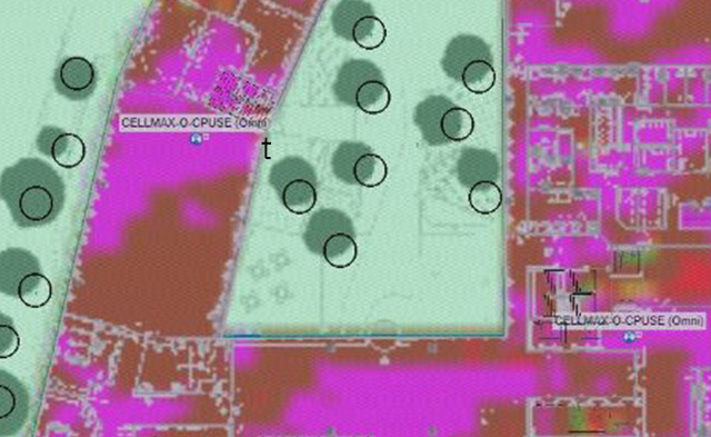
DASCAD provides planners with the ability to upload a DAS design and the macro network surrounding the DAS location then run studies to see how the DAS system performs. The results can help planners improve SINR, throughput, and mobility.
DASCAD can perform scenarios that help planners see the impact of their proposed adjustments before and after the changes are implemented. The tool can also show the impact on KPIs like RSCP, SINR, and throughput for each change made.
Yes, planners can use DASCAD to upload the current macro configuration, run their predictions, and fine-tune their prediction model with their test data. Then, DASCAD presents final predictions (and their impact on KPIs) to help planners collect “before and after” data.
Yes, DASCAD allows planners to upload their study sites alongside geocoded traffic data to produce recommendations to improve traffic loading.
Yes, DASCAD helps planners test their small cells design. To start, planners can upload their macro network and then place their small cells in test locations to determine the most effective configuration. DASCAD also helps planners conduct field surveys and design closeout packages.
Yes, planners can upload their existing DAS design into DASCAD, including the macro network around the location. From there, they can use DASCAD to study how the DAS system interacts with outdoor and indoor conditions. The results of these studies can help planners improve key metrics like SINR, throughput, and mobility.
To run DASCAD, you’ll need a computer running Windows 8 or 10, an I7 processor, 32 GB RAM or higher, 500 GB disk space or higher (we recommend a solid-state drive), and a dedicated graphics card.
Yes, DASCAD has a mobile application that allows planners to view projects in the field, add comments, and collect project data.